Zhöl Wall
This is the wall that runs around inner Zhöl (zhol), the village located at the base of the Potala in Lhasa. It has the shape of three sides of a rectangle and runs from the west side of Marpori south, forms a ninety-degree angle and turns east and runs to the edge of inner Zhöl, where it again forms a ninety-degree angle and turns north, running to the east side of Marpori. It separates inner Zhöl from outer Zhöl, and built within it are the west, east, and main Zhöl gates as well as buildings at the corners of the village.
Feature Type
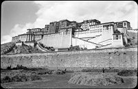
South face of Potala with wall surrounding Zhöl village in the foreground. Copyright Pitt Rivers Museum, University of Oxford 1998.131.302


